සීගිරිය
SIGIRIYA
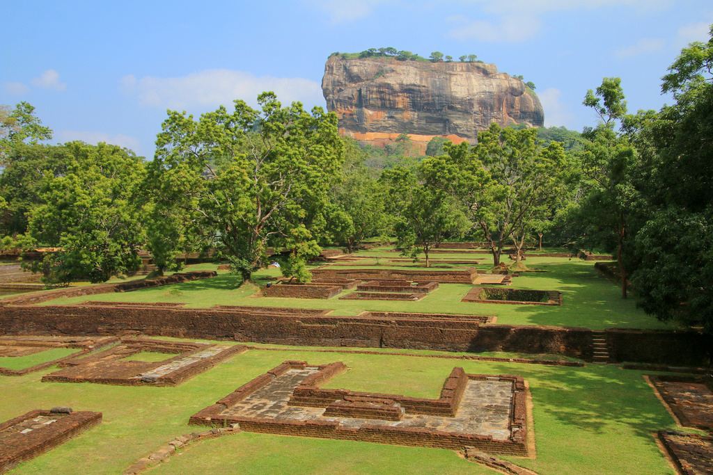
සීගිරිය හෝ සිංහගිරි යනු ශ්රී ලංකාවේ මධ්යම පළාතේ දඹුල්ල නගරය අසල උතුරු මාතලේ දිස්ත්රික්කයේ පිහිටා ඇති පැරණි ගල් බලකොටුවක් . මෙම නම සඳහන් වන්නේ ඓතිහාසික හා පුරාවිද්යාත්මක වැදගත්කමකින් යුත් ස්ථානයක් වන මීටර් 200 ක් (අඩි 660) පමණ උසැති පර්වතයක දැවැන්ත තීරුවකින් ආධිපත්යය දරයි. පැරණි ශ්රී ලාංකික පුරාවෘත්තය චූලවංශයට අනුව , මෙම නව නගරය සඳහා කාශ්යප රජු (ක්රි.ව. 477 - 495) විසින් මෙම ස්ථානය තෝරාගෙන ඇත. මෙම පර්වතය මත තම මාලිගාව ගොඩනඟා, එහි පැතිවල වර්ණවත් බිතුසිතුවම් අලංකාර කළේය. මෙම පර්වතයට උඩින් අඩි තුනක් පමණ කුඩා සානුවක ඉදිමී ඔහු විශාල සිංහයෙකු ස්වරූපයෙන් දොරටුවක් ඉදි කළේය.
මෙම ස්ථානයේ නම මෙම ව්යුහයෙන් උපුටා ඇත. සිංහ සිංහයා සිහගිරි. රජුගේ මරණයෙන් පසු අගනුවර සහ රාජකීය මන්දිරය අතහැර දමා ඇත. 14 වන ශතවර්ෂය වන තුරු එය බෞද්ධ රජමහා විහාරයක් ලෙස භාවිතා කෙරිණි.
වර්තමානයේ සීගිරිය නගරය යුනෙස්කෝව විසින් ලෝක උරුමයක් ලෙස ලැයිස්තුගත කර ඇත. පුරාණ නාගරික සැලසුම් පිළිබඳ හොඳම සංරක්ෂණය කළ එක් උදාහරණයකි.
Sigiriya or Sinhagiri is an ancient rock fortress located in the northern Matale District near the town of Dambulla in the Central Province, Sri Lanka. The name refers to a site of historical and archaeological significance that is dominated by a massive column of rock nearly 200 metres (660 ft) high. According to the ancient Sri Lankan chronicle the Culavamsa, this site was selected by King Kasyapa (477 – 495 CE) for his new capital. He built his palace on the top of this rock and decorated its sides with colourful frescoes. On a small plateau about halfway up the side of this rock he built a gateway in the form of an enormous lion. The name of this place is derived from this structure —Sīhāgiri, the Lion Rock. The capital and the royal palace was abandoned after the king's death. It was used as a Buddhist monastery until the 14th century.
Sigiriya today is a UNESCO listed World Heritage Site. It is one of the best preserved examples of ancient urban planning.